
This post may contain links to products that we use and love, and we may earn a commission at no cost to you.
Henline Falls Trail currently CLOSED due to the 2020 Beachie Creek Fire.
As we researched hikes for the summer, one hike appeared again and again. It was like this echo with vague details, promising a stunning waterfall AND a creepy abandoned gold mine. But first, I had to find it, and I had no idea what it was called. I feel like I’m giving away a precious secret writing about this magical place, but I promise you I am not… Henline Falls and the Silver King Mine are pretty easy to find, both online and in person. And better still, both of our newest hiking guides list it as a “best hike for kids”.
Henline Falls is less than an hour east of Salem, off Highway 22. At nearly 2 hours from the Eugene/Springfield area, it’s absolutely worth the drive.

Henline Falls is a unique experience that your kids will talk about all summer long. At least, mine still are.
History of Silver King Mine
Usually I write the history at the end of posts, but for this hike, I think it’s more fascinating if you know the history of what you’ll see.
Developers began promoting the Silver King Mine sometime in the early 1900s, and a road was completed into the area in 1916. They built a 5-foot Pelton water wheel in (or very near) the waterfall itself provided up to 85 horsepower of electricity, and perhaps as much as 200 HP if later reports are accurate. (1, 3) Nearby, a cement power plant supplied electricity to the mine’s hydraulic drill, with which they eventually blasted 1700 feet of tunnel straight into the mountainside. Miners called this tunnel the “Queen Vein” after what was thought to be a rich vein that included gold, silver, lead, and zinc. (1)

Miners sit outside the entrance of Silver King’s Queen Vein, the very same entrance you’ll see when you hike to Henline Falls. (1)
Outside the tunnel, they built 300 feet of track and had one ore car. Ten men could work in the mine at a time, utilizing picks and shovels. A 1916 Mine Report references buildings “on property”, but I am unsure if these buildings were at the waterfall site, or somewhere downstream. The mine report states that up to 12 men could be accommodated. (1)

This engineer’s drawing from a 1916 Mine Report shows the approximate locations of the power plant, the mine entrance, and the waterfall. (1)
The Silver King Mine set out to sell 500,000 shares, and produced an investor Mine Report in 1916 with thorough explanations of the veins and samples taken from the mine. The Mine Report implored would-be investors to consider their own futures, and to invest wisely in the Silver King Mine. The report admitted that many mines were a bust, but ensured that Silver King was the real deal. (1)

This stock certificate is dated 1914. (2)
The Silver King Mine closed in 1938. All told, the Silver King Mine and all of the nearby mines together produced only 1000 ounces of gold, worth less than $25,000. (4)
Henline Falls Trailhead
I recommend visiting Henline Falls during the week. The trailhead only has parking for about 3 cars, and signs warn that no parking is allowed along the road. We squeezed into a space and everyone spilled out of the van, ready to hike off some energy.
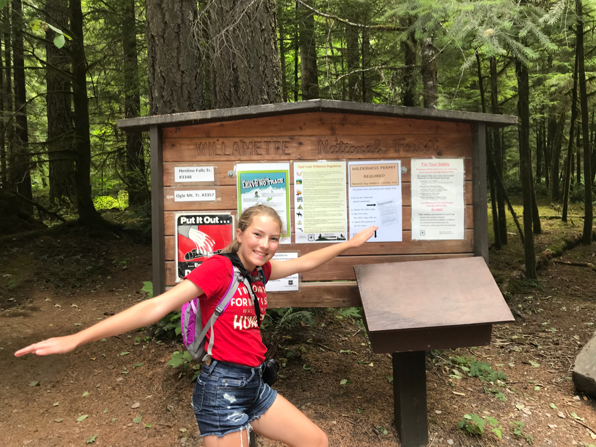
The trail head for Henline Falls is just before entering a wilderness area, so be sure to register before you hike.
Henline Falls Trailhead does not have any amenities. No restrooms are available, but just a mile or so back down the road is a wide parking area with an emergency phone (make note of that…no cell phone reception anywhere) and a vault toilet. Henline Falls is located inside a wilderness area, so the Forest Service does require a self-issued wilderness permit. This is free and you can do it right at the trailhead. Why bother, and what business is it of theirs anyway? Not only does it help them to determine use patterns (hello, more parking, please!) but it also aids in search & rescue, especially during wildfires. The Forest Service will know how many people to look for, and generally where.
There’s also no trash service at Henline Falls, so pack it in, pack it out. Leave no trace, and if you can, leave it better than before.
Henline Falls Trail
The trail is wide, flat, and easy for most of the hike. Our kids ran along the trail, and the trail is so wide that we could hold hands with two kids at once. In many places, you can tell that this used to be a road, probably from the 1920s when the mine was running, and maybe more recently for logging. The trail meanders through a lovely forest with lots of wildflowers of various colors. I still haven’t learned what all the flowers are yet (can anyone recommend a good guide?) but suffice to say, there were at least half dozen different kinds of blooming flowers along the trail. Purple, white, and yellow mixed with lush greenery.

Ferns line the trail to Henline Falls, along with various wildflowers. Soaring fir trees provide shade and glimpses of blue sky.
Eventually, the trail narrows a bit, and we walked single file. The scenery changed a bit and we started to climb. The elevation change isn’t severe, and we weren’t breathing hard. Soon, we could hear the rushing creek, long before we actually saw it.

Easy hiking, even as the plants close in on the trail. You feel like you’re leaving civilization behind, and truly, you are.
The last 0.1 mile of the trail, it really narrows and gets a little hairy. You’ll hear the waterfall, but you won’t see it quite yet. The trail is a little steeper, but almost any level of fitness will do just fine (trust me, I’m fluffy and I don’t look like your typical hiker). Hold your kids’ hands at this point, because the dropoffs are also steep.

The last bit of trail is rockier and steeper. There are dropoffs, so hold hands with little ones.
And then…you see it.
Henline Falls
The first thing you’ll see are a few bulky concrete structures with rebar blocking the trail. These are remnants of the old power plant that provided the electricity for the drills for the mine.

These were the concrete footings for the power plant that fed electricity to the mine. Photo credit: Camille.
Navigate carefully, as the footings are right up against the hillside and form a tight squeeze. This is the only “tight” spot on the trail, and there’s nothing here that’s sharp or inherently dangerous. Use caution and you’ll be just fine.

From the concrete footings to the base of the waterfall is about 300 feet. Below the falls is a wide pool and a broad beach. The logjam behind it all creates a safe haven for little ones…they truly can’t get far very fast so it’s a great spot to let them roam and explore. The water was c-c-c-c-old in June, but we did see some other hikers with towels and swim suits. We were lucky enough to be alone the whole time we were there, but it’s roomy enough to share with other visitors!
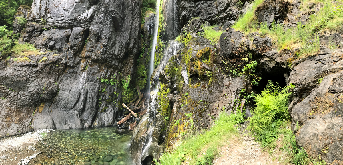
This panorama shows both the mine entrance and the 125-foot waterfall.

Henline Falls drops 125 feet into an aqua splash pool. Water levels were low for our trip, but the sound of the falls made a lovely backdrop for our visit.
The water is crystal clear, and the rocks below the falls are a variety of colors. If you’re into rock hounding, I’m sure you’ll appreciate the array of rocks at Henline Falls.

The pool is crystal clear and a gentle depth, perfect for a swim if you can handle the cold.
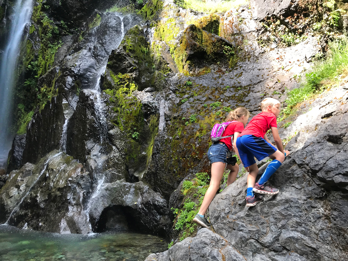
If your kids are anything like mine, they’ll want to be inside that mine. And since this is a Forest Service wilderness area, they can! There’s a faint path up to the mine entrance, or you can scramble up the rocks like billy goats.
Silver King Mine
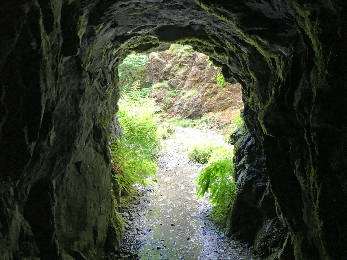
The entrance of the mine, or more technically, the adit, is about 20 feet above the beach. As you look around the canyon, you’ll see other possible adits…I know there were quite a few at one time so I imagine these probably were alternate entrances or maybe test holes. This adit is the Queen Vein and it’s safe — and legal — to enter.

The entrance is solid rock, lined with ferns and moss. A little moisture trickles out of the entrance, but it’s not discolored as some mine seepage can be.
It’s allowable to enter the mine up to about 40 feet. Then there’s a bat gate, erected by the Forest Service to protect both visitors and the bat habitat within. But 40 feet is plenty of space to explore what a mine might have been like 100 years ago. Look around…do you see any critters? What grows on the walls?


The mine is completely pitch dark this far in. My daughter’s camera flash lit it up for a split second, but otherwise we could see nothing at all without a flashlight.
I almost feel like this photo is a juxtaposition of two opposite worlds: the bleak stark coldness of the mine, and the lush and bright vegetation of the canyon.
While inside the mine, we did see a little wildlife. I nearly jumped out of my skin, but my 14-year-old informed me that these were merely cave crickets. I wasn’t sure whether to believe her, so I kept my distance. Google later confirmed that she was, of course, correct. Just crickets.
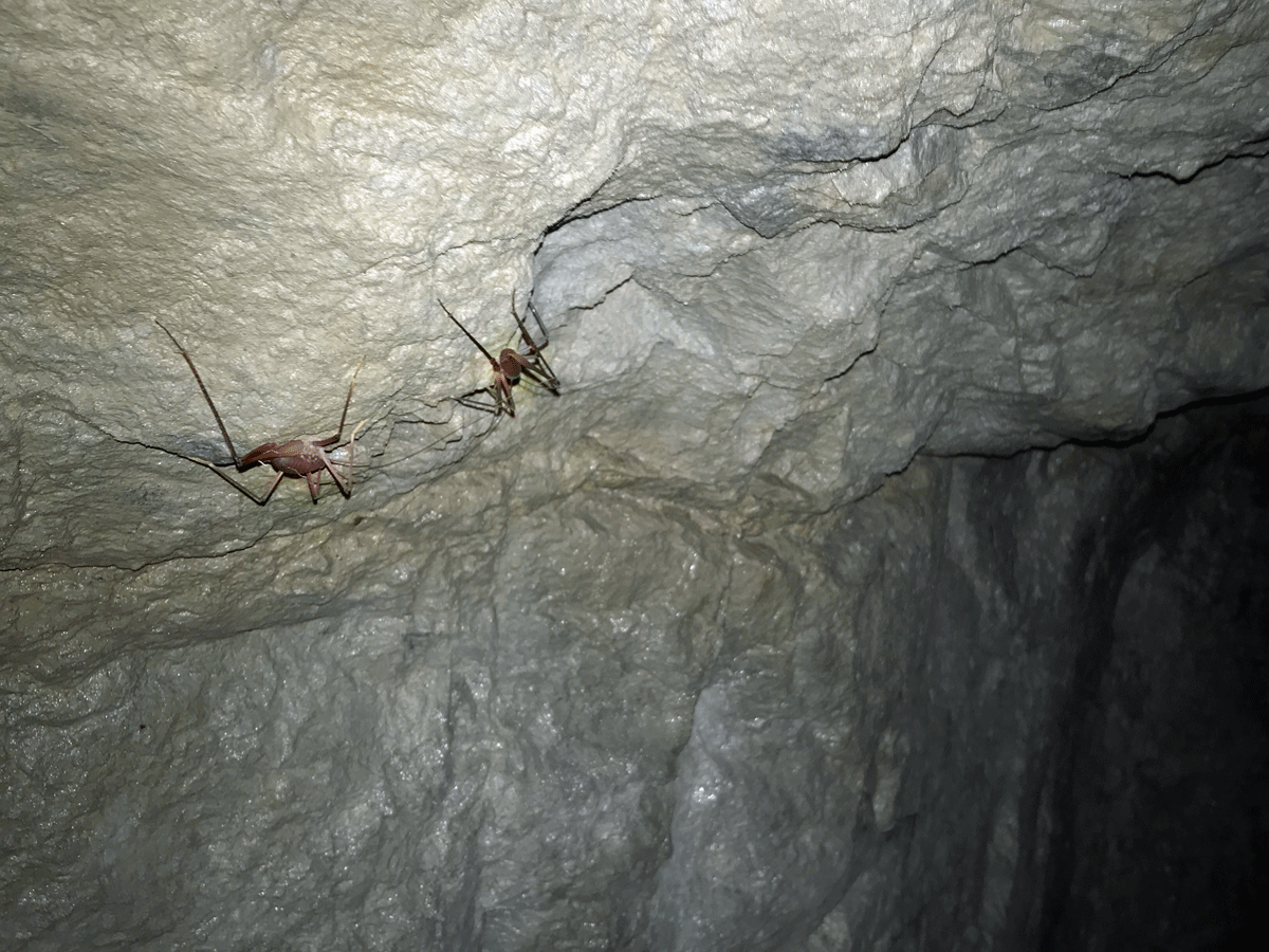
Just crickets, I promise.

My husband found this happy little guy on the floor of the mine cave.
My husband was less concerned about what might eat him and more thoughtful about taking photos, and he found some interesting things, besides critters.
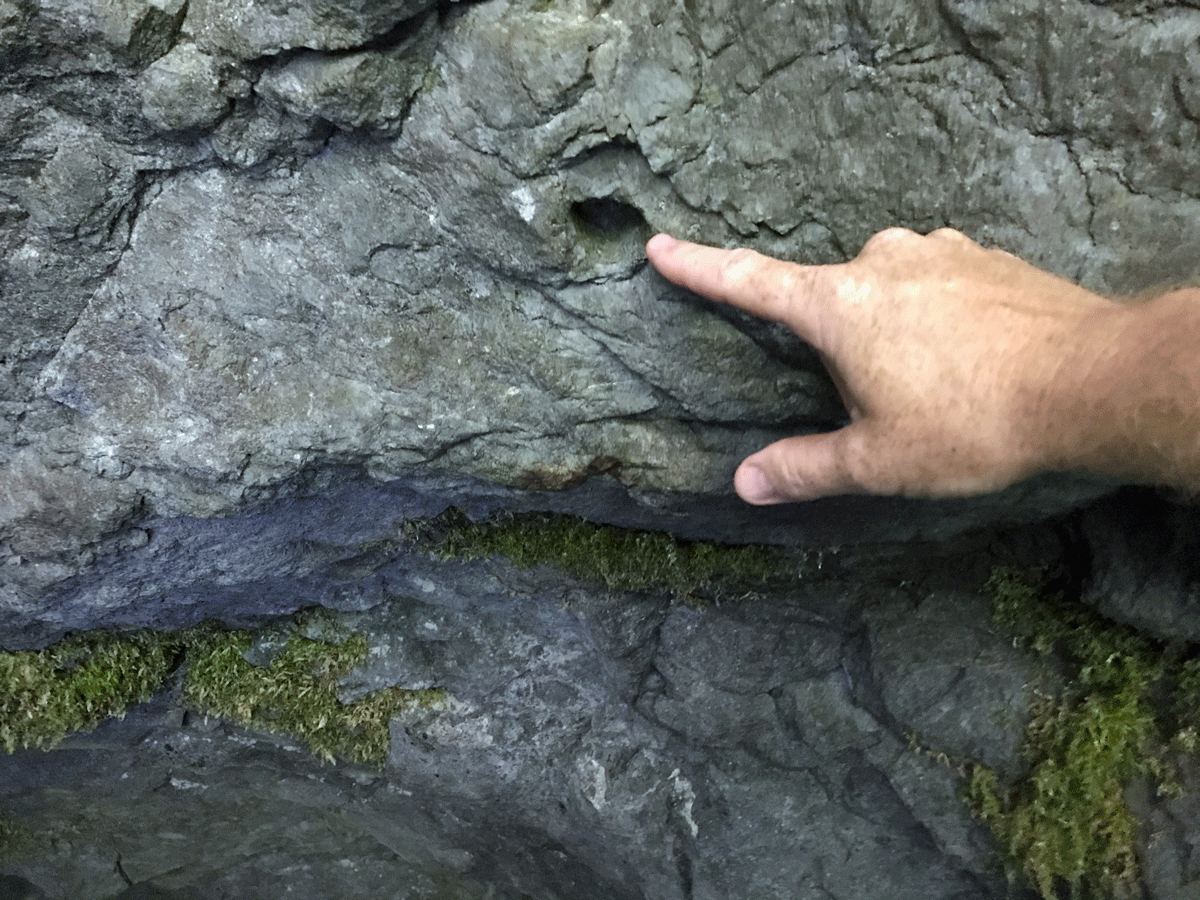
Lining the walls of the mine are these little holes, perfectly drilled. I am assuming these were for dynamite, but I don’t know for sure.

Simply the floor…you can see that it’s rough but nothing really to trip over. And damp, but no running water. The mine is astonishingly clean inside, no debris or litter.
Videos of Henline Falls and the Silver King Mine
While we were there, we each took a few videos. Here are my favorites that show a great overview of what the falls and mine are like.
Let’s go!
If you go, and I hope that you do, here are some further details:
TRAIL CLOSED DUE TO 2020 WILDFIRE. For official updates, visit https://www.fs.usda.gov/r06/willamette/recreation/henline-falls-trailhead
updated 2/23/2026 Still Closed with no update for when it might reopen.
Fee: none
Parking: free, but only enough spaces for 3-4 cars, and no parking on the road
Restrooms: none at the trail head, but there are vault toilets 1-2 miles down the mountain
Stroller & Wheelchair Accessibility: none
Cell reception: none, but there is an emergency phone located 1-2 miles down the road
Forest Service information: https://www.fs.usda.gov/recarea/willamette/recreation/recarea/?recid=4247
Directions:
From Salem, Oregon, travel east on Highway 22 to milepost 23. At the Oregon Department of Forest Office on the left, turn left on North Fork Road, which is marked Little North Santiam Recreation Area.
Travel about 17 miles to the Forest Service Road 2207 junction, continue past this junction for 1/4 mile. Trailhead is on the left.
References:
1. Mine Report (1916) https://www.oregongeology.org
2. Old West History Store http://www.oldwesthistorystore.com Photo of stock certificate.
3. Cox Jr., James B. (1985) Little North Santiam Mining District Cultural Resources Inventory
4. Brooks, Howard and Ramp, Len (1968) Gold and Silver in Oregon
2 comments
The fire damage prohibits access to this trail. The road is closed. Too bad I didn’t know that before driving two hours.
Oh nooooo! I’m so sorry! I’ve heard the area is opening up slowly, so hopefully you found another great hike to do.